Preston's Windmills
Part 2
Following on from a previous post about a search for historical windmills around Preston in Lancashire, I continued to keep a watch for anything related when reviewing other historical information.
At the point of publishing the last post on the subject, I had pinpointed the location of eight windmills around the town using the first edition Ordnance Survey Maps from the 1840s.
- Factory Windmill (Moor Lane tower mill)
- Friargate Windmill
- Margaret Street Windmill
- Park Lane Windmill
- Parr Croft Windmill
- Singleton Row Windmill - now known as Craggs Row and the tower still exists
- Snow Hill Windmill
- Cadley Moor Windmill
As per the first post, much of this history happened before the advent of photography, so there was no photographic evidence for any of the windmills other than the tower of Craggs Row windmill. There are no photographs of this windmill with the sails still intact either. However, there were a number of very good illustrations, which appeared to portray a pretty accurate picture of the topography at the time. These were generally seen within landscape paintings, engravings and etchings from the early nineteenth century. These depicted panoramic views of the town from the north, south and west.
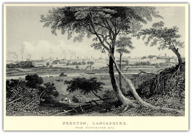 |
| Preston, Lancashire from Penwortham Hill |
This image (above) is from Preston, Lancashire, from Penwortham Hill (engraving). The artist is Harwood, J. This illustration was for a publication called 'Lancashire Illustrated' and was made circa 1831. It appears to have been engraved by Benjamin Winkles from an original study by John Harwood.
It is relatively easy to identify the location of seven windmills on this illustration, which is looking toward the town from the west. However, at this stage, it would be more difficult to positively identify which is which from the earlier list. This would probably discount Cadley Moor Windmill as it was further to the north and would probably have been out of view beyond the left of the illustration. The following image is a cropped view from the illustration. On this image, I have identified the windmills by placing a circle around them and numbering them. They are just ordered numerically from left to right. The numbers don't necessarily correspond to the order of the first list at the beginning of the post. I may refer to this series of number at a later date, if I feel I can put an accurate name to each one.
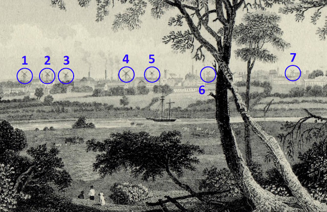 |
| Preston, Lancashire from Penwortham Hill Illustration with Numbered Windmills |
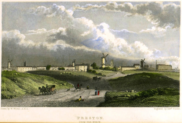
Another illustration, looking towards town from the north, shows four windmills on the landscape. The approach to town is still very rural, and the windmills can be seen in amongst the first of the cotton mills.
This is a print from an etching showing a view of the town of Preston in the distance with several windmills, different figures on a road in the foreground, a carriage to left; after W. Westall. I understand that the print was made by Edward Finden from William Westall's illustration.
Some other illustrations became apparent, where the windmills formed part of the backdrop but were not the centre of attention. The first one was an illustration of St Mark's Chapel, Preston, Lancashire. This building still survives, and is in use as a place of worship today. It is on Pole Street and you are able to see a windmill to the right of the building, which would have positioned it to the north. This would make it the Margaret Street Windmill.
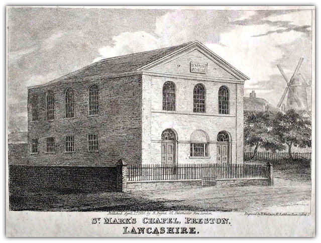 |
| St Mark's Chapel, Preston, Lancashire showing Margaret Street Windmill |
This building is now know as the Carey Baptist Church. It was formerly a chapel for Methodists of Countess of Huntingdon's Connexion, and was built in 1826. It is recorded in the National Heritage List for England as a designated Grade II listed building, and is now affiliated with the Baptist Union of Great Britain.
See the Historic England listing: https://historicengland.org.uk/listing/the-list/list-entry/1207315
The Connexion is the legacy of arguably the most influential woman in the Evangelical Revival that swept England and America in the 18th century. Counting John Wesley and George Whitefield among her closest friends the Countess of Huntingdon was driven by a desire to share the Good News of Jesus Christ with her generation. By the end of the century in which she lived she had formed The Connexion of chapels and mission stations across the United Kingdom.
Another image that shows a windmill as part of the backdrop in an illustration of 'The Preston Strike', showing Mr. George Cowell addressing an open air meeting of factory operatives in the orchard. The orchard was an area of the town to the north of the Flag Market (then Market Place) that was known as "Chadwick's Orchard" and is where 'Orchard Street' gets its name from.
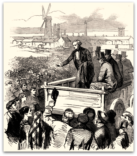 |
| The Preston Strike - George Cowell Addresses Factory Operatives |
The Preston cotton strike and lockout of 1853-4 was a significant trade union cause of the time. It was comparable to the miners' strike of the 1980s. A notable difference was that the cotton workforce, while led by males, was majority female. Spinners and weavers in Preston fought an epic eight-month long battle with their employers, with the support of trade unionists across the region and beyond. It had a devastating effect on the town and community of Preston, and its impact was felt nationally. Such was it's social impact, that it was written about in a number of fictional works from the era, by now famous authors.
One of the descriptions accompanying the 'Preston Strike' image says that the church tower seen next to the windmill is that of Trinity Church. Preston Holy Trinity was a created as a chapelry from, and laying within the ancient parish of Preston St John, in the county of Lancashire, built by 1816. The church had closed by the 1950's and was demolished in 1951. The Church was situated on a site known as Patten Field, Snow Hill. That would strongly suggest that the Windmill depicted was the Snow Hill Windmill.
%20Preston%20Sheet%2011.gif) |
| Snow Hill Windmill Adjacent to Trinity Church |
Going back to the maps. When researching the post about historical horse racing in Preston, I was pointed in the direction of some older maps of Lancashire that where made prior to and independent of the Ordnance Survey work. These were namely;
- A map of the County Palatine of Lancaster
from 1828 by Mapmakers G. Hennet & James Bingley. - The county Palatine of Lancaster (centre south west sheet)
from 1786 by Mapmakers William Yates & Thomas Billinge.
Both of these older maps (pre Ordnance Survey first edition) showed the Cadley Moor Windmill. However, the Yates/Billinge 1786 map indicated another windmill closer to the centre of Preston is an area known as Greenbank (Green Bank). None of the windmills previously identified are situated as far to the west as that. This area was to the north of Fylde Road and the Lancaster Canal and would be approximately where the Goss Printing Machinery Works was located in later years. This printing press factory was demolished in 2015.
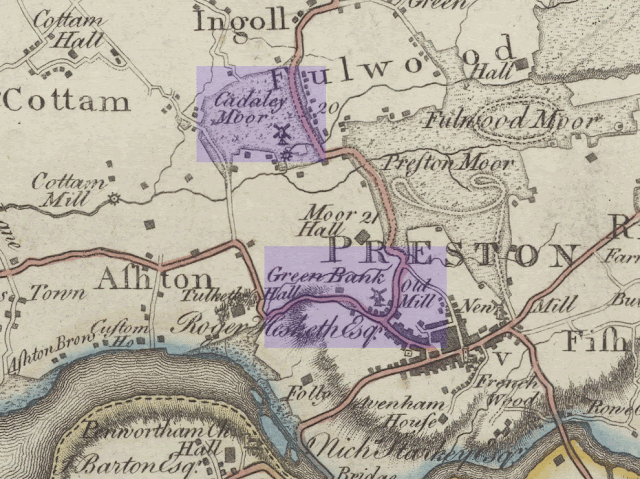 |
| The county Palatine of Lancaster 1786 - William Yates & Thomas Billinge |
The county Palatine of Lancaster map was surveyed by William Yates, engraved by Thomas Billinge and printed on 8 sheets ca. 69 x 55 cm (ca. 27 x 20 inches) in 1786.
The final piece of illustrative work that sheds some light on the subject is an illustration by Terry Rushworth, based on Richard Kuerden's map of Preston circa 1680. This map shows two windmills it is possible that the one to the northwest is the Friargate Windmill. However, it shows another one to the south. Going back to the original post, this very likely ties in with the Sike (Syke) Hill windmill. There is also a PDF document that I have been looking at that appears to confirm this.
 |
| Artistic Visualisation of Kuerden's Preston Map 1685 by Terry Rushworth |
Preston 1685 - Reconstructed from sketch plans found at Townley Hall in the 1950s and now held at Lancashire Archives in the DDX194 collection.
Image courtesy of the Preston Historical Society - www.prestonhistoricalsociety.org.uk
The final comment on this map, is that the PDF shows a windmill that the above illustration by Terry Rushworth doesn't appear to include. The symbol for a windmill is indicated to the east of the junction between Fishergate and Alms House Lane. I understand Alms House Lane to be where Mount Street is now. This would suggest that the windmill might be at the top of Fishergate Hill. I don't know if this would be far enough to the west to be considered as the Broadgate Windmill.
At this stage, I will wrap up the investigation. However, I'd be interested to find out more. It seems unlikely that other pictures of any of these windmills would be unearthed, but it's not impossible. I'd also like to understand a bit about the people who were working in the windmills, their ownership and the sources of the corn that they were grinding.
To be continued...
---------------------------------------------------------------------------
Singleton Mill belonged to my Great Great grandfather, Henry Walker, in the early 1840s.There were several reported fires. He moved onto a state of the art steam mill in Walker Street but still suffered from fires (!) and became bankrupt.
ReplyDelete