Preston's Windmills
Part 1
I have always been interested in windmills. We are fortunate to have a number of surviving examples dotted around Lancashire, and some of them are in a state of good repair. The ones on the Flyde Coast including Marsh Mill at Thornton-Cleveleys, Little Marton Windmill and Lytham Windmill are all well known. I can't recall having been inside any of these buildings, but I might have done in the past. The last working example I had the pleasure of viewing the inner workings of was on the outskirts of York. This was Holgate Windmill, which is York's last surviving windmill and apparently the oldest five-sailed windmill in the country. That's certainly worth a visit. It's also quite unique, in the sense that it is on an island in a street, surrounded by houses.
I have only really recently become aware of the history of Preston's windmills. Something led me to Craggs Row Windmill several years ago, whilst on one of my journeys down a rabbit hole on the World Wide Web. I don't remember passing it at any point in my younger days. I suppose it would have been hidden by the taller buildings that surrounded it. Whilst travelling on Adelphi Street, Friargate, Moor Lane and Walker Street, I can't say that I ever noticed it. From that point of view, the first time that I definitely recall seeing it was in May 2021.
 |
| Craggs Row Windmill (formerly known as Singleton Row) |
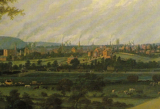
More recently, whilst paying attention to a number of pictures (paintings) that were popping up on local Social Media groups, and visiting a local digital archive hosted on Flickr, the number of windmills visible on the landscape was quite remarkable. The number of windmills, in a very concentrated area, seemed particularly high. The following extract from a painting that currently belongs to the Harris Museum & Art Gallery, called the "View of Preston from Penwortham Hill", John P. Jenkinson (1790–1821). This shows many windmills visible on the landscape.
View of Preston from Penwortham Hill by John P. Jenkinson (1790–1821)
Harris Museum & Art Gallery
 |
| View of Preston from Penwortham Hill by John P. Jenkinson |
I found reference to seven at first. These came from some very detailed town maps from the middle of the nineteenth century, and were as follows:
- Factory Windmill (Moor Lane tower mill)
- Friargate Windmill
- Margaret Street Windmill
- Park Lane Windmill
- Parr Croft Windmill
- Singleton Row Windmill (now known as Craggs Row)
- Snow Hill Windmill
These are all located around a relatively small area, which is contained within the modern day streets (or roads) of the Ring Road (A59), Friargate, Moor Lane and North Road (A6).
I had accounts for a larger number in some written records but, whilst a good effort of identifying them had been made by somebody who was not local to the area, based on the names he'd supplied there were some duplicates. For example, the researcher made reference to Sedgwick Street mill, Kirkham's Mill and Sedgewith Street mill, which I believe all refer to Park Lane Windmill that would have been on Sedgwick Street.
Evidence of five of these windmills can be seen on the following Ordnance Survey Maps of the area. The map can be viewed on the National Libraries of Scotland website.
Map 1 - Preston Sheet 11
This map contains evidence of the Factory, Friargate, Parr Croft, Singleton Row (Craggs Row) and Snow Hill Windmills.
The map was surveyed in 1847 and published in 1849.
(Railway revision to c. 1856). Reprinted: 1882
Size: map 64.4 cm x 96.6 cm (25.344 x 38.016 inches), on sheet ca. 72 x 104 cm (ca. 28 x 41 inches)
Map 2 - Preston Sheet 12
This map contains evidence of the Park Lane and Margaret Street Windmills.
The map was also surveyed in 1847 and published in 1849.
(Railway revision to c. 1856).
Size: map 64.4 cm x 96.6 cm (25.344 x 38.016 inches), on sheet ca. 72 x 104 cm (ca. 28 x 41 inches)
A Preston Historic Town Survey, which was produced as part of a Lancashire Historic Town Survey Programme in February 2006, suggested that the were nine windmills around the town. The 'Assessment Report' stated the following:
"The town was noted for its windmills, and Preston had become the principal corn milling centre for the area by the late eighteenth Preston century."
It goes on to say:
"There were 9 windmills operating in the town by the mid nineteenth century (Ordnance Survey Maps 1849)"
In addition to the windmills seen Preston Sheet 11 and Preston Sheet 12 Town Maps, I was able to locate the Cadley Moor mill by referencing another map. This was one of the Ordnance Survey Lancashire County Maps, Sheet LXI (61) showing Fulwood and Preston.
Map 3 - Lancashire Sheet LXI
Surveyed in 1844 to 1847 and published in 1849
Size: map 61 x 92 cm (ca. 24 x 36 inches), on sheet ca. 70 x 100 cm (28 x 40 inches)
My research has also thrown up a further three possible names. These are Broadgate mill, Sike Hill mill (more likely Syke Hill mill) and Townende Mill. However, I have not been able to find much, if any, written evidence and can't find them on the maps. Perhaps they were gone by the time of the OS surveys, between 1844 & 1849.
I can see evidence of other Windmills on different maps that I have recently found that don't correlate to the positions of the ones that have already been identified. This may account for the ones that don't match up.
The Windmills on the Map
Base on the OS 1849 Preston Town Maps, Sheets 11 & 12, the following images show the windmills on the map in closer detail.
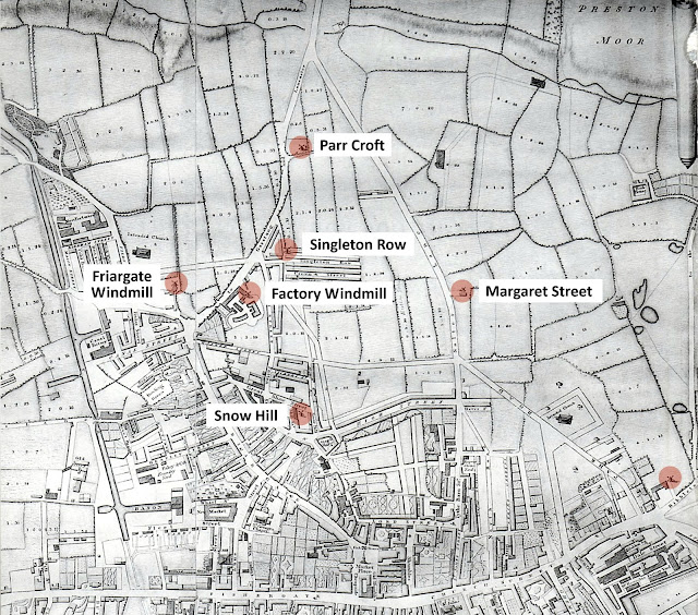
As far as how they were located relative to each other, I discovered a map that illustrated them all together and highlighted the positions. However, there were a couple of differences. The first thing that doesn't match up is the location of the Margaret Street Mill or the Park Lane (Segdwick Street) Mill. One of them appears to be missing. I think this is the Park Lane windmill at his stage. There is a Salter Lane on the 1822 map, which seems to line up with Lancaster Road on the 1849 map. The position of the easternmost windmill is on Salter Lane (this section of Road is now known as Lancaster Road North). Also, Park Lane isn't yet in existence on the 1822 map. This is likely to be because Moor Park to the north of Preston hadn't been created. Therefore there wouldn't be anything adjacent to that road, such as the windmill at Sedgwick Street. Park Road already exists in 1822, but it doesn't connect to Park Lane at the north, as it does on the later maps.
Also, this map seems to identify the position of another windmill that didn't appear on the 1848 OS maps. This is located at the west end of Ribbleton Lane and the south end of Deepdale Road. Could this be the missing Townende Mill?
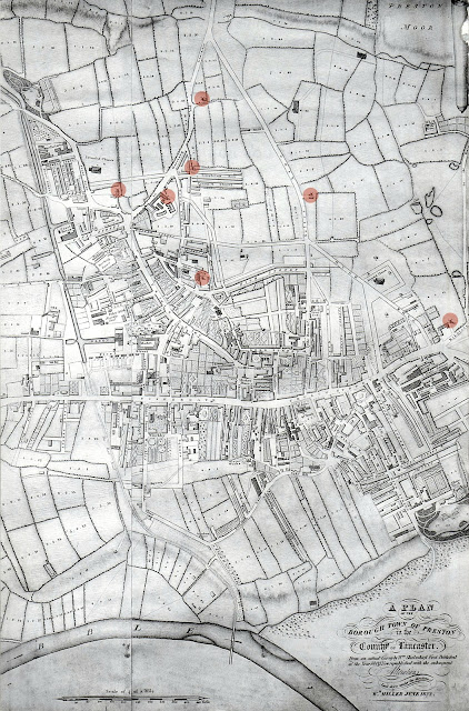
The Map of Preston 1822 (extract) can be seen in the Preston Digital Archive's Flickr collection. The extract is from William Shakeshaft's map of 1809, which was revised by William Miller in June 1822. Marked as points of interest are the locations of several of the town's former windmills. They are marked in red.
Map of Preston 1822 (extract) on Preston Digital Archive:

Extract from William Shakeshaft's Map of Preston 1822
I have produced a cropped version of the extract from William Shakeshaft's Map of Preston 1822, which now only includes anything north of Fishergate. I have labelled the six windmills that definitely correlate between the two different maps.
 |
| Extract from William Shakeshaft's Map of Preston 1822 with Names |
Could the windmill to the far east relative to the others be the missing Townende Mill? Based on the name 'Town End', that seems to fit in with it's Geographical location. It certainly is at the (east) end of town. An argument against this, is in some information relative the the early Winckley Square.
"Winckley Square was the brainchild of the Preston attorney William Cross who purchased Town End Field from Thomas Winckley. Mr Cross built the first house on the square in 1799 – now number 7. He named the Square after the Winckley family. It was developed by Cross as an exclusive residential area."
That would suggest that 'Town End' was south of Fishergate.
Where Would the Windmills be Today?
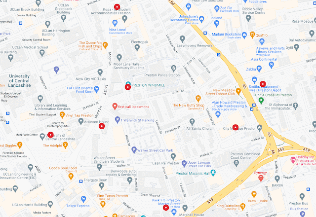
To wrap up, I have included an pair of maps using a list of What3Words locations that plot the windmills situation on a modern day map and satellite image. The locations would be approximately in the middle of the base of the tower.
 |
| Preston's Windmills - what3words map of locations |
what3words Windmill Locations
- ///bake.desks.lasted - Snow Hill Windmill
- ///inch.learns.glaze - Friargate Windmill
- ///again.relate.human - Factory Windmill, Moor Lane
- ///bands.daring.eating - Singleton Row Windmill
- ///rests.deeply.scenes - Parr Croft Windmill
- ///jumpy.speak.beyond - Park Lane Windmill, Sedgwick Street
- ///upgrading.tend.topic - Margaret Street Windmill
 |
| Preston's Windmills - what3words locations on satellite image |
---------------------------------------------------------------------------
My accounts of the local area - About this Blog


%20Preston%20Sheet%2011.gif)

%20Preston%20Sheet%2011.gif)
%20Preston%20Sheet%2012.gif)
%20Preston%20Sheet%2012.gif)
%20Preston%20Sheet%2011.gif)
%20Preston%20Sheet%2011.gif)
%20Preston%20Sheet%2011.gif)


