The Hidden Viaduct of the
Lancashire and Yorkshire Railway
The Old Railway Line
On a personal level, I am familiar with the Lancashire and Yorkshire Railway, or at least the disused sections around Preston and South Ribble. I used to cross a section near Bamber Bridge on may way to school in the mid nineteen-seventies, and I am sure that there were still a few goods trains pulling loads of oil tankers crossing Brownedge Road (Brownedge Lane) that occasionally stopped us if I'd gone to school on the 113 bus. Passenger services had long since stopped and when the goods trains had also ceased, the rail company ('British Rail') quite quickly removed the infrastructure. This was definitely the rails and sleepers, but perhaps not the ballast straight away. From that point forward, it became the playground of a few of the local children, myself included.
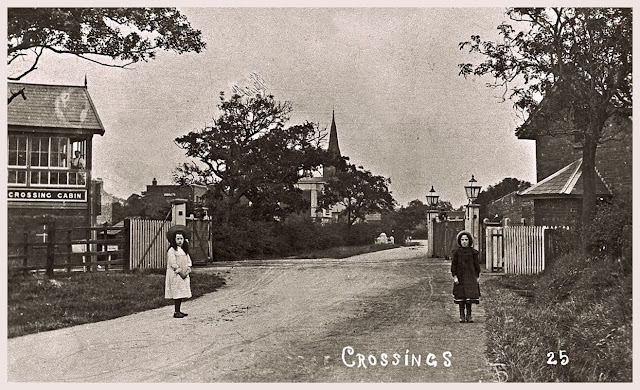 |
| Brownedge Level Crossing, Bamber Bridge around 1905 |
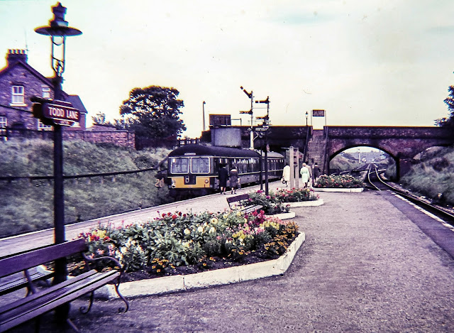
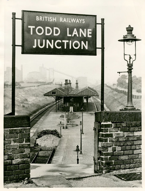
At that point, we often would have adventures in the remains of Todd Lane Station. The stone steps from Todd Lane North down to the the platform were starting to collapse, but safe enough to walk on and there was a room of sorts underneath that we used as a den. All of this has now gone. The station was removed and the bridge on Todd Lane North, over the former railway line, was infilled. The whole area has been gradually re-sculpted. It now forms part of a traffic free route from South Ribble into Preston. This included in the Sustrans Cycle Route NC55. Route 55 runs in sections between Ironbridge and Preston via Telford, Newport, Stafford, Macclesfield, Stockport and Wigan or Bolton.
 |
| Todd Lane Station |
 |
| Photo by Roger Sutcliffe Showing the Disused Todd Lane Junction Station |
View the above image on Flickr: https://flic.kr/p/9rjVA4
The next image is a 1965 photograph of Todd Lane Railway Station when it was line was still in service under British Railways control. It is approximately the same view as Roger Sutcliffe's photo. The viewpoint is just a little bit further north (only by a few metres, or yards if you prefer). In the distance, the outline of the former Gas Works on Wateringpool Lane can be seen.
 |
| Todd Lane Junction Railway Station near Preston August 19, 1965. |
The routes of the former lines can be seen on the following map. This is from RailMapOnline, which is an excellent free website that aims to provide an interactive map of all historic railways for the UK and US. Here I am using the UK part of the map. The former Lancashire and Yorkshire Railway can be seen represented by a green line. The current working west coast mainline can be seen in orange.
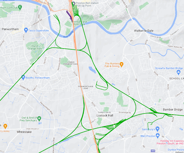 |
| RailMapOnline - Lancashire and Yorkshire Railway Line |
If you would like to explore the map in more detail, this link will take you to the map. I have centred it on the Lancashire and Yorkshire Railway Line in South Ribble, but you can explore further by zooming in and out and moving around north, east, south and west.
Moving further North-West from Todd Lane, the former railway line approached the valley of the River Ribble. This can be seen on the previous map. Up until recently, I had only really thought of the railway crossing the valley on top of quite a tall embankment with a few arches to allow a handful of minor rights of way to pass under the line. There were branches off to Penwortham taking the railway into west Lancashire. When you get to the River Ribble, you can see a large viaduct with several arches on the south side of the river and one arch on the north side in Preston where the line cuts through in-between Avenham and Miller Parks.
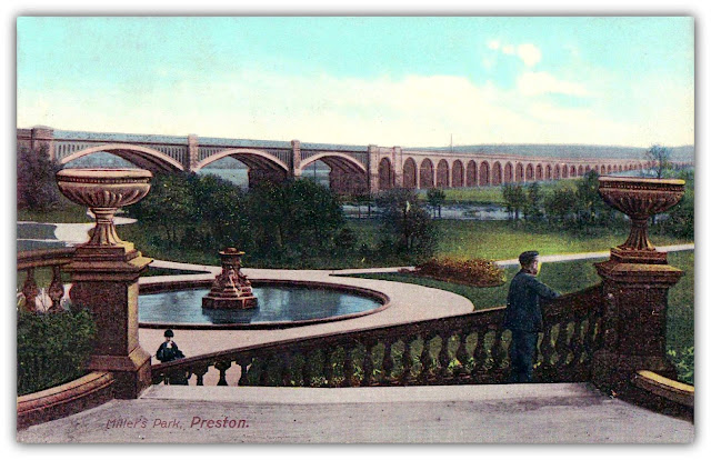
However, this was not always the case. In recent years, I have been looking at a lot of historical photographs and paintings of the area. This led me to discover a common theme. This was initially on paintings from roughly the middle of the nineteenth century. From that point of view, I assumed that there may have been a bit of 'artistic licence' been exercised. My opinion on this changed when I started seeing photographs from the same era that had been taken in around Avenham and Miller Parks facing southwards. It was clear to see that not only did the paintings depict are large number arches on the viaduct further south than we know today, the photographs were showing them too. One of the first images that I saw that clearly showed a large number of arches was this Tinted Postcard of Miller Park in Preston from the Preston Digital Archive. This is from a time the viaduct was known as 'The Blue Bridge'.
 |
| East Lancashire Railway Viaduct Across the River Ribble Valley |
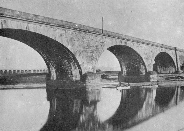
The next photograph shows them clearly. This is another image from the Preston Digital Archive. It is a photograph Photograph by Robert Pateson, and shows the North Union Railway Bridge Preston in 1862.
 |
| North Union Railway Bridge Preston in 1862 |
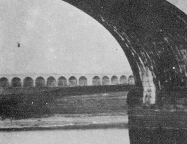
The North Union Railway Bridge Preston in 1862 is viewed from the North bank of the River Ribble, from a location roughly where the Continental Public House is now. This before any widening. The railway viaduct carrying North Union Railway over River Ribble became a British Rail viaduct. It was built in 1837-8 and then widened 1879-80, with subsequent further addition. It still carries the West Coast Mainline today. The masonry from the viaduct of the East Lancashire Railway line can be seen in the distance through the left hand arch. Zoomed in, it looks like this.
 |
| East Lancashire Railway Viaduct seen through Railway Bridge Arch |
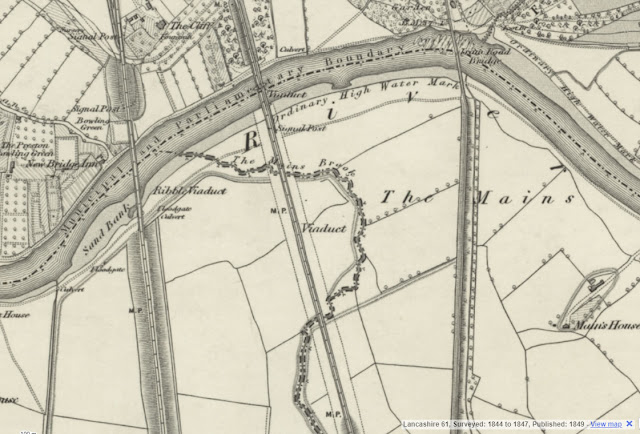
Looking at an Ordnance Survey from the time an indication of the viaduct can be in an area known as 'The Mains'. This comes from the Ordnance Survey Six-inch Map 1st edition, Lancashire Sheet LXI. The area was surveyed between 1844 & 1847and the map was published in 1849.
 |
| The Mains - Ordnance Survey Map Published 1849 |
What Happened to the East Lancashire Railway Viaduct?
So, what happened to the East Lancashire Railway Viaduct? If you look at the first picture of the East Lancashire Railway Viaduct seen in it's original form, with the viaduct running south of the river Ribble, close inspection reveals the noticeable sag. This caused so much trouble that eventually the viaduct was encased within an embankment. Ultimately, there must have been problems with the foundations of the structure across the whole valley. Thinking back, even though I personally didn't know that the viaduct is still there hidden under the embankment, there were signs. The sides of the embankment are very steep. If the structure was just an embankment with no internal support, I am sure that it would have had to have been wider with a much shallower angle. Otherwise, the whole thing would have just collapsed.
In more recent years, some of the arches that were still visible have been demolished. I presume at the time of making the various paths and cycle routes in the area, they must have deemed unsafe.
I have read that when the viaduct was constructed in 1846 it originally had 52 arches before they were filled in. I can't find any other information to confirm this. Of the arches that are still there under the soil of embankment, small signs of them can be seen. If you leave the section of the visible bridge spanning the River Ribble heading south, on your right-hand side (the west side or Penwortham side) there are a group of dressed stone slabs that once lined the viaduct route. One has a large section chipped away, and this reveals a plate on the end of a tie-rod. If you climb over it, you can see the top of one of the filled in arches.
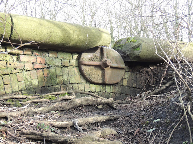 |
| The Top of One of the Buried Arches is Exposed. |
On the other side of the track there is a path that leads down to the south bank of the river, people have been cutting the corner in several places and that too has started to expose some of the brickwork that lies beneath.
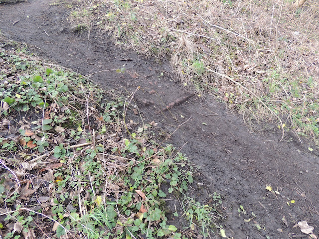 |
| Shortcut Exposing the Buried Brickwork of the Viaduct |
As mentioned before, some arches remained exposed. Ignoring the ones that are adjacent to the south bank of the River Ribble, all but one of those were demolished. At the time of the 1840s map, this arch would have served no specific purpose. However, a later map (published in 1913) shows that there was a sports field on the east side of the railway in the mains area. This is specifically a Cricket Ground that had a pavilion. I presume that the railway company were under an obligation to main access to the field.
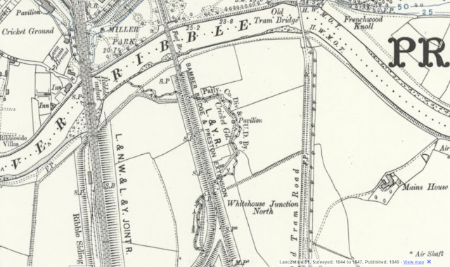 |
| Whitehouse Junction North - Ordnance Survey Map Published 1913 |
This comes from the Ordnance Survey Six-inch Map Lancashire Sheet LXI.SW. This was revised in 1909 and published in 1913. The full map [ Size: map 31 x 46 cm (ca. 12 x 18 inches), on sheet ca. 43 x 58 cm (ca. 17 x 23 inches) ] can be seen on the NLoS (National Library of Scotland) website: https://maps.nls.uk/view/101101877
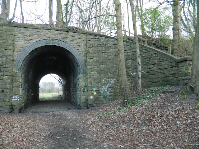 |
| The Blue Bridge Arch |
---------------------------------------------------------------------------
A very good article here, a very interesting bit of local, and railway history. You've obviously put a lot of work into researching this, thank you. I lived near Colne at one time, and used to travel to Preston an occasions, by rail, through the Bamber bridge area. I'm mindful that Lostock Hall was one of the last steam sheds (Motive Power Depot's) still in use in Britain before BR's ban on steam in 1968. So much of our railway heritage has been trashed in the name of progress. I never knew about this wonderful viaduct. It's a pity it wasn't built on firmer foundations, that way it wouldn't have had to be buried. Still, nice to see views of how it used to look.
ReplyDeleteThank you very much for your positive comment. It is nice to read your memories about the area. I was brought up near the sheds in Lostock Hall, and would often go to sleep at night to the dull 'purr' of the ticking over diesel engines. Steam had gone by that point. You might also be interested to know that I originally thought trains going east in your direction were heading to 'Cologne'. To be fair, I was only about six or seven, and I think it was pretty good for me to know that Germany was to the east.
Delete