Gamonia - Or to give it its full title,
'Gamonia: or, the Art of Preserving Game'.
Gamonia is a book about game shooting that is renowned for its detailed descriptions of game preservation and hunting practices. The book features illustrations by J. T. Rawlins, depicting various hunting scenes in Penwortham in the estate of Penwortham Priory. The word "Gamonia" appears to have been coined specifically for the book and does not seem to have a broader historical or linguistic usage outside this context.
 |
| Gamonia - Penwortham with conclusion of a Battue |
.
Penwortham Priory was first a Benedictine priory and then, after the Dissolution of the Monasteries, a country house. The latter was demolished a hundred years ago.
The Rawsthorne family lived at the Priory from 1783. In the mid-19th century they employed the architect George Webster to redesign the house. This architect also designed Bank Hall at Bretherton.
 | |
| Penwortham Priory from the LCC Red Rose Collections |
The book Gamonia is attributed to Lawrence Rawstorne, but there is little evidence that he wrote it. There is a suggestion that the writer assumed his name to give the publication credibility. It was published some 13 years after Rawstorne’s death. If it was written based on his manuscript, or at least some journals Rawstorne wrote, it would be likely that the preface or introduction would explain this. That's not the case. If he were the author, it would be the only known work by him, which seems unlikely given the depth of knowledge in the book.
Personally, I do not favour the activities depicted in the book. However, from a local history perspective, it is a very interesting piece of work.
 |
| Penwortham West End of the Four Acre |
Within the publication, there are numerous references to many places in and around Penwortham. This includes several local woods which can be seen on Ordnance Survey First Edition Maps from 1848. They include Round Wood, Lower Ridding Wood, Four Acre Wood and Blashaw Dam Wood.
 |
| Ordnance Survey First Edition Maps from 1848 (NLoS) |
With regard to the book's illustrator, there are a number of other attributions that suggest that J. T. (or T. J.) Rawlins was an active illustrator and lithographer in the 19th century, contributing to various publications and artworks beyond Gamonia.
 |
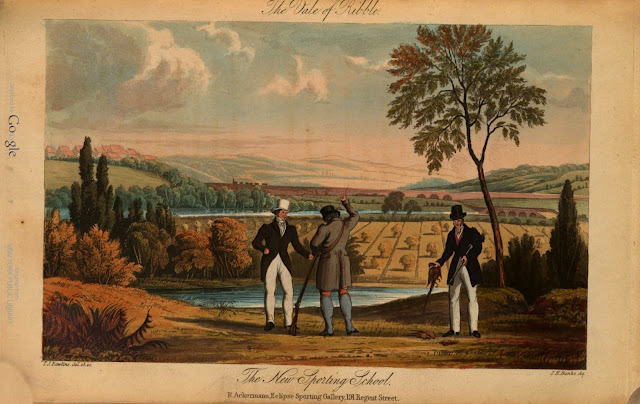
| The Vale of the Ribble - The New Sporting School |
 |
| Penwortham - Muff a Favourite Retriever |
I first came across three of the illustrations when looking for information about Tulketh Hall. Whilst the activities in the publication do not venture across the River Ribble from Penwortham, the hall at Tulketh can be seen in the distance on some of the pictures.
I first saw the one that mentioned Tulketh Hall on Peter Smith's Preston History website last year, and just assumed to was a 'one off' painting, because the captions from the book had been cropped off. Whilst he does mention a book about game birds for shooting, and has some footnotes about it, I didn't notice them at the time. A bit more digging into Tulketh Hall recently revealed the other plates (pictures).
There are 15 illustrations set all around Penwortham at the time, through Howick and towards Longton. The house at Howick is now the location of Galloway's Society for the Blind. The current building resembles the one in the illustration, so it's possible the 19th century house still exists and was extended.
![Howich [House] from Blashaw Wood Howich [House] from Blashaw Wood](https://blogger.googleusercontent.com/img/b/R29vZ2xl/AVvXsEhVFhPYSilGWZKrWtRcXiKoxE64UBITGedHi_XxkMdjQROmKwVXp_vq5byVzckOeMRIKUDT6U_CZi7hAVLlroAEACuzJ6bBexckZ7uCtHzJKCVJ8GWYtewOWwTpFQjPQOsNPlV7Ybs2Le6ofwZ0GcSVEKdJmyzR43vjLpXD2405rJYiZWo3K6uv7Sc7w0U/w640-h408/Howich-From-Blashaw-Wood.jpg) |
| Howich [House] from Blashaw Wood |
 |
| Howick House is now the location of Galloway's Society for the Blind |
Penwortham Priory does not appear to have been in a ruinous state when it was demolished in 1925. It still seems to have been a substantial and well-maintained country house at the time of its demolition. The decision to demolish it was not due to structural failure but rather for economic reasons. The estate was sold off, and the house was cleared to make way for new development. The site of the Penwortham Priory Estate is now largely occupied by Priory Park and modern housing. The land on which the Penwortham Priory Country House once resided is now occupied by the properties around Hollinhurst Avenue, Hollinhurst Crescent and Priory Crescent.
~
Sources of information and further reading
Gamonia: or, the Art of Preserving Game is available online for free. The Internet Archive provides access to a digitized version of the 1837 edition, which you can read or download here:
https://archive.org/details/gamonia-or-the-art-of-preserving-game-1837/page/n5/mode/2up
.
Gamonia, or, The art of preserving game : and an improved method of making plantations and covers, explained and illustrated / by Lawrence Rawstorne, Esq. ; with fifteen coloured drawings by J.T. [sic] Rawlins, taken on the spot
https://hdl.handle.net/2027/nyp.33433066630884
.
The story of Tulketh and Tulketh Hall - Preston History
https://prestonhistory.com/subjects/the-story-of-tulketh-and-tulketh-hall/
.
Penwortham Priory -
The Lancashire County Council Red Rose Collections
https://redrosecollections.lancashire.gov.uk/view-item?i=239833
.
Houses of Benedictine monks: The priory of Penwortham
https://www.british-history.ac.uk/vch/lancs/vol2/pp104-106
.
Ordnance Survey First Edition Maps from 1848
National Library of Scotland
.
~
Comments
Post a Comment