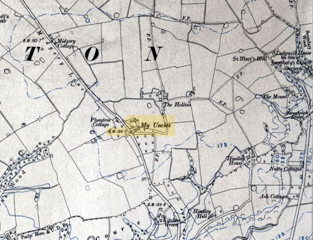
My Uncles (The Easter Egg)
I have always liked looking at maps from planning bike rides, walks, road trips, holidays, etc. to just looking at them out of sheer curiosity. More recently the Internet opened up even more opportunities with things like freely available satellite images and street views. It is only a few years ago when someone made me aware of old maps that had been digitised and published online. It's been a real 'virtual' adventure looking at them. Particularly the early Ordnance Survey Maps from 1848 and (around) 1910. The ability to view them and compare them to modern maps and satellite image really helps bring the history to life.
So far, I have tended to focus around Lancashire and Preston specifically, being a local and all that. I thought I had spotted most things of interest already, but on Monday April 1st 2024 I stumbled across this gem. I am still trying to work it out. What on earth is going on?
 |
| My Uncles was in Fulwood off Midgery Lane |
I am sure that somebody somewhere was having a secret laugh to themselves about this one. How does an official Ordnance Survey map end up with a place called 'My Uncles' on it? 🤔
 |
| My Uncles was in Fulwood off Midgery Lane |
Was it somebody's Uncle's place? One of the cartographers, or maybe the surveyors. It all seems very strange. Hence the 'Easter Egg' reference. I have worked with computers for quite a while in one way or another, and I came across this term when working with Microsoft Office 97 Excel. This (effectively at the time) accounting software contained a hidden flight simulator.
In computer software, Easter eggs are secret responses that occur as a result of an undocumented set of commands. The results can vary from a simple printed message or image to a page of programmer credits or a small video game hidden inside an otherwise serious piece of software.
I wonder if I have stumbled across a similar thing going on in the mapmaking world? It's all very curious. Alternatively, was it a local pulling the surveyors' legs? I can just imagine the conversation, something along the lines of...
Surveyor: "What is this place?" (to a local)
Said Local: "That's My Uncles".
...and the rest is history.
"Where is My Uncles?", I hear you say. I will refrain from retorting, "If you don't know, how am I bloomin' supposed to?", or similar. My Uncles was situated in Fulwood. It was just to the east of Midgery Lane. That section of Midgery Lane is now part of the Guild Wheel. I have passed the spot many times. It does not feature on the 1848 OS map, but is present on the one published 1913. Specifically it is Lancashire Sheet LXI.NW that was revised in 1910 and published in 1913, from the Ordnance Survey Six-inch England and Wales, 1842-1952, series. These maps come courtesy of the National Library of Scotland (NLoS) and the specific sheet can be viewed here:
https://maps.nls.uk/view/101101853
I don't think that I have missed something obvious, that everybody knows about except me. A few Internet searched have turned up very little, so I don't think it has another meaning that has somehow passed my by. Either way, I found it quite amusing.
I have also notice that it was present on the OS maps surveyed from 1891 to 1892 and published in 1895. The Benchmark indicated as B.M. 184.3 possibly would have been on the corner of one of the buildings that constituted part of 'My Uncles'. I would say that this was approximately in this location.
What3Words: ///snack.chops.fleet
Longitude, Latitude: 53.793944, -2.685101
Grid Reference: 354967, 433288
After some discussions with local people online, I received the following feedback:
Valentine:
"Passed this house many times in my childhood, it was actually called “My Uncles” there was a sign outside, I never found out why."
Paul:
"We never did find out either."
"My Grandad farmed there from 1935 until it was demolished around 1980. Before that it was farmed by the Singletons from about 1880 ish. Before the Singleton's it was occupied by Kenyon's who was my Great Great Grandad. I've some old photographs of the farm but unfortunately they aren't scanned."
Somebody pointed me in the direction of an article listing properties in the area by the Central Lancashire New Town Development Corporation in the THE LONDON GAZETTE, 22ND MAY 1973. This includes a reference to "My Uncle's Farm". This is an image from the top of the page, which was online as a PDF document.
 |
| Agricultural land "My Uncle's Farm" Midgery Lane - LONDON GAZETTE MAY 1973 |
This was scanned into the Gazette Official Public Record online. This can be seen here:
https://www.thegazette.co.uk/London/issue/45983/page/6412/data.pdf
I'll come back to the New Town Development Corporation in future posts. They were at the time in offices at Cuerden Pavilion, Bamber Bridge, Preston, PR5 6AZ.
---------------------------------------------------------------------------
References
Lancashire Sheet LXI.NW that was revised in 1910 and published in 1913, from the Ordnance Survey Six-inch England and Wales, 1842-1952, series. See the National Library of Scotland website:
https://maps.nls.uk/view/101101853
To compare this to a modern map or satellite image, see the National Library of Scotland Side by Side viewer:
---------------------------------------------------------------------------
Comments
Post a Comment