Who was Todd of Todd Hall?
No, I am not mistyping or misspelling a reference to a Kenneth Grahame character. 'Who was Todd of Todd Hall?' is a question about the origins of the name that an old house that is local to me in an area south of Preston in Lancashire, which is currently known as South Ribble. My previous post called 'Todd Hall a Listed Building Dating Back to 1630' is about the same topic, although it only briefly mentions my curiosity about the origins of the name.
I had been speculating the the name Todd doesn't really have anything to do with the origins of the house, and perhaps refers to a later owner. The name has left a mark though, as the road that runs nearby (we'll come back to this point) had been called 'Todd Lane' since at least the mid eighteenth century. It is shown as this on the first Ordnance Survey maps of the area dating back to 1848. Another road that joins it, to the south, at a junction of 'Four-Lane-Ends' had been called 'Moss Lane' in the same time period. However, this had changed at some point. The revised OS map from 1909, still shows the same name. In recent memory, the lanes have been known as 'Todd Lane North', which Todd Hall is on and 'Todd Lane South'. I am unsure why the name needed to change. I can't see that there was a naming conflict with any other roads locally. The same thing has happened on the roads that Todd Lane intersects. These were 'Brownedge Lane' and 'Black Lane'. The former has retained its name, but Black Lane has become 'Brownedge Road'.
Todd Hall has always been a property that I have been fond of and curious about. I have always lived nearby and passed many time visiting my Grandparents who resided on Green Drive. This road runs east from (a loops back round to) Todd Lane North, adjacent to Todd Hall. In recent years the curiosity has extended to the origin of the name. I currently just can't find any information about anybody who owned land or property in that area with the name of Todd. Looking at some older maps, albeit with less detail than the OS ones, there doesn't appear to be anything that indicates the name Todd.
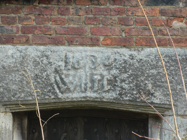
Looking at the datestone of the house, which dates back to 1630, there were four initials. Whoever had surveyed the property initially for Historic England, formerly known as English Heritage, had noted the initials to be W(?) IC. I had a look at them and thought that the second letter may be a quiet narrow 'H'. As well as the character on the datestone resembling the 'H' to my eyes, there was also a couple of other pieces of information that were leading me to that conclusion.
 |
| Todd Hall datestone showing the date 1630 and possibly the initials WHIC |
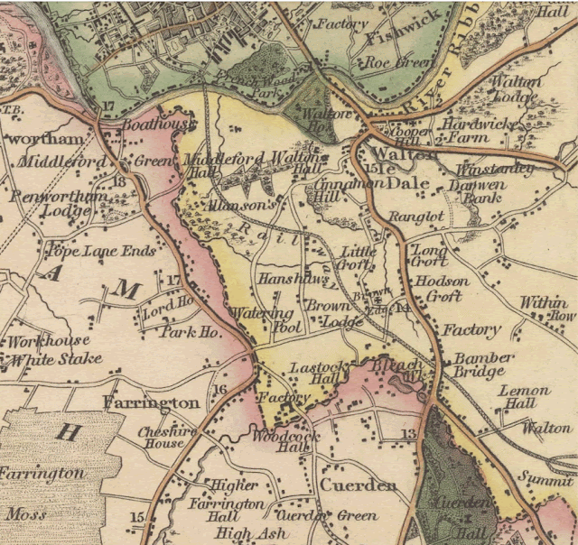
The first bit of information was from 'A map of the County Palatine of Lancaster' from an accurate survey in the year 1828 by G. Hennet & James Bingley. This makes a reference to the name 'Hanshaws' in the area where the Hall is. There is no mention of the name Todd. I wondered if the possible H on the datestone was a reference to 'Hanshaw'.
 |
| Section from G. Hennet's & James Bingley's 1828 County Map |
The full Map of the County Palatine of Lancaster, made in 1828 by G. Hennet & James Bingley is available from the National Libraries of Scotland:
https://maps.nls.uk/view/220113211
Another piece of information came from pages 289-300 of 'Townships: Walton-le-Dale', in A History of the County of Lancaster: Volume 6, (London, 1911) that I found on the British History Online website.
The following section makes reference to the name 'Hanshaw Hall':
A portion of the estate appears to have passed to Richard le Serjeant of Walton, about 1400, by his marriage with Amabel daughter and heir of Hugh de Haydock. The estate of Law House was in the possession of the Serjeant family in 1461. (fn. 80) The name is of frequent occurrence until the middle of the 17th century. Before 1650 Richard Serjeant of Middleforth died possessed of Hanshaw Hall in Walton, which passed to his seven daughters and co-heirs. In 1662 the heirs of Richard Serjeant paid 14d. puture rent to the honor of Clitheroe for 'Manehouse'—that is, Mosney House. Leonard Serjeant, descended from another branch of this family, died in 1640, leaving several daughters his co-heirs, of whom Katherine was the wife of Richard Sharrock. William Sharrock, probably a kinsman of Richard, suffered forfeiture for recusancy, but petitioned in 1653 for a reversal, alleging that 'God by His marvellous light has discovered to your petitioner the deep and erroneous ways of the Popish religion wherein he was bred.' He had taken the oath of abjuration, and was a frequenter at church.
I wondered if 'Todd Hall' should actually be 'Hanshaw Hall' as referred to in this text. The timeframe is correct, because Richard Serjeant's death before 1650, could still be after the property was built in 1630. There are references to a John de Hanshaw, an earlier John de Hanneshagh occuring in 1332 and also a Richard de Hanneshawe. My speculation led me to think that the possible WH was a descendent of these Hanshaws. I am still trying to find any other details about anybody named Hanshaw in the area, which historically came under 'Walton le Dale'. So far, online searches have been fruitless.
A third piece of information came from a document about Deer Parks in the Forest of Bowland. A page from the detailed survey of 1651 (TNA E 317 Yorks 49), which is held a The National Archives, contains the following text:
'Memorandum Herbage & pannage of Radholme Park, besides Whitewell green & Foster Close, was granted to Sir James Fullerton knight 30 March of the 12th anno Jacobi [ie 12th year of James I’s reign, 1615] for the term of 60 years; Sir James by deed on 24 Nov 12th anno Jacobi assigned the same to Wm Hanshaw esquire, the said William by his deed of 20 June 14th anno Jacobi assigned his interest to Richard Halsall, said Richard by his deed of 1st Sept 14th anno Jacobi assigned his estate therein to Anthony Parker who with his deed of 6th Sept 14th anno Jacobi [1617] upon the marriage of his daughter to John Parker of Bradkirk, Lancs, assigned his estate in the premises to said John Parker. John Parker now deceased & estate in possession of Christopher Parker. John’s son, Christopher Parker, for Radham Parker, Whitewell green & Foster Close pays an annual rent of £17, 6 s., 8 d. but are worth with improvement as well as said rent per annum: £146, 2 s, 6d'
It is obviously not in the same area as Todd Hall, but it does confirm that somebody know as Wm (William) Hanshaw esquire was somebody who owned hunting land approximately 15 years prior to Todd Hall being built. It possible that he would still be alive in 1630. Could this be our 'WH'?
Another interesting aspect of the property is just that, its aspect. It is a relatively large property and would have been quite grand at one point. It really doesn't have any 'frontage' and the walls of the building are at a very peculiar angle compared to the front wall that is next to the pavement (and adjacent road). I have, in the past, wondered about this. However, I hadn't really considered it at length. Recently, I posted some pictures of Todd Hall online on a Local Facebook Group. Following that, somebody pointed out the position relative to the road (Todd Lane North) and said that a previous road would have followed a different course and Todd Hall would've been on that road and would have had a parallel alignment. The road he made reference to was an ancient Roman Road that ran right through the area, from Wigan to a settlement by the River Darwen and its confluence with the River Ribble in Walton le Dale. I had a look at previous work in this area, and could see there had been some archaeological excavations locally in the 1990’s. They revealed a very impressive section of this particular Roman road. It headed south directly towards Todd Lane in Lostock Hall and Stanifield Lane just north of Leyland. It is hard to explain, but I mentally could not picture the two roads lining up in any way. I have travelled them many times and know that I have to turn right out of Stanifield Lane and travel roughly 200 yards (metres) to the east to get to Todd Lane South. How can they possibly line up then. One thing my mental map had not accounted for is the fact that Todd Lane South deviates quite a way back to the west as you travel along it.
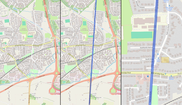
I had a look at some projects on maps where somebody had previously drawn the line of the route. I could see it, but the image was quite small and was very pixelated when I attempted to zoom in to see the detail. I decided to take a screenshot of OpenStreetMap and have a go at the exercise myself. I was quite surprised at the result. Everything did actually line up and the position of Todd Hall made more sense.
 |
| 3 Maps showing the position of a Roman Road and Todd Hall |
The above image shows three maps indicating the position of a Roman Road and Todd Hall. The map at the right is directly from OpenStreetMap. The middle map shows a straight line that I have plotted from Stanifield Lane to the south and Todd Lane (South & North). The third map, to the right, is a more detailed section zoomed in directly next to Todd Hall. A number of sections of the Todd Lanes definitely line up with Stanifield Lane and Todd Hall is positioned parallel to the projected line of the Roman Road through the area.
It is hard to determine why the current route of Todd Lane South took such a massive deviation. It is possibly relative to later land ownership of the establishment of bridging points. I believe that the Roman Road would have forded the River Lostock. It is a relatively small river, and there is still a ford in pretty much the same location where the Romans would have crossed. I have embedded an Ordnance Survey (OS) Six-inch Map below. It should load at the appropriate location on Lancashire Sheet LXIX.NW that was revised in 1909 and published in 1912.
You can see the deviation in Todd Lane South, then known as Moss Lane, around 'Ivy Cottages' and 'Pearson's Farm'. The reminder of the road travelling north up to Todd Hall lines up with the road coming past the former Woodcock Hall from the south.
What can now be seen as the 'Stepping Stones' across the River Lostock, or Dandy Brook as it is known locally, is approximately at the position the Romans would have crossed the river via a ford. The modern satellite image below shows them. Their route is northwest/southeast, but the ford would have been on a more northerly/southerly alignment.
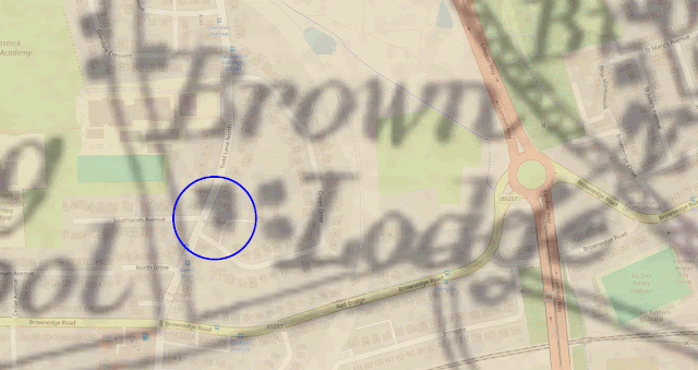
Whilst looking at this Roman Road alignment. I went back to the Hennet & Bingley 1828 County Map. One thing that I had not previously realised was that the map had been georeferenced, which means that I should be able to lay it on top of (over) or underneath a modern map or satellite image for comparison. When I did this, it revealed that my Hanshaws conjecture might not be viable. The location marked on the old map that most accurately lined up with the location of Todd Hall on modern maps and satellite images was identified as Brown Lodge. This is something that I had previously looked at, but discounted following by initial line of enquiry. Another piece of information that I had gleaned from my Local Facebook Group post was that somebody who lived next to the hall paid ground rent to a member of the Landed Gentry, or British Aristocracy, at a local but more substantial hall.
A man commented as follows:
"It was built by the Hoghton Tower owners as a hunting Lodge ( it must have been surrounded by woods in 1630). We live next door and pay ground rent to Hoghton Tower, our house was built by the Tower owners in 1902."
That gives me a new line of enquiry, although I had briefly looked for any connections to the 'de Hoghton' baronets. They were historically major landowners in the area and I had seen other properties around (old) Walton-le-Dale with datestones related to Sir Richard Hoghton, this would normally be displayed as "R de H". Again, initial web searches on this topic are not proving to be very fruitful. The map with Brown Lodge can be seen below for reference. I have circled Todd Hall from the OpenStreetMap (OSM) Overlay.
 |
| OpenStreetMap Overlay of Brown Lodge on Hennet & Bingley Map |
Whilst I have gathered a lot of interesting information on this topic, I have yet to find any conclusive evidence about the origin of the Hall. The search continues.
 |
| Todd Hall - The Mystery House on Todd Lane North |
If you would like to look at some of the background information yourself, I have listed a number of my sources below.
--------------------------------------------------------------------------------------------------------
The Wigan Archaeological Society Project Blog Roman Road between Wigan and Walton-le-Dale.
https://www.wiganarchsoc.co.uk/blog/?page_id=125
Pages 289-300 of 'Townships: Walton-le-Dale', in A History of the County of Lancaster: Volume 6, (London, 1911) that I found on the British History Online website.
https://www.british-history.ac.uk/vch/lancs/vol6/pp289-300
Forest of Bowland Deer parks Final report April 2013 (PDF)
https://www.forestofbowland.com/files/uploads/pdfs/FOB-Deer-parks_Final-report-Apr-2013.pdf
The full Map of the County Palatine of Lancaster, made in 1828 by G. Hennet & James Bingley is available from the National Libraries of Scotland:
https://maps.nls.uk/view/220113211
---------------------------------------------------------------------------
Comments
Post a Comment