The History of Brockholes -
Before and After the Preston Bypass
The area of Brockholes, to the east of Preston along the Ribble Valley, is relatively well-known these days for its now well-established Nature reserve. It is somewhere I visit relatively often these days. Strangely, it tends to be more frequent during the winter months. There are generally more things demanding my attention when the weather is warmer, hopefully drier and the days are longer. The main attraction for me during the late autumn and winter for me are the Starling Murmurations.
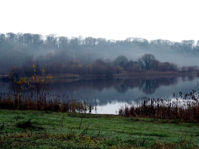 |
| Brockholes in December 2018 |
During the winter months, large numbers of starlings visit Britain from the continent, seeking out the relative warmth of our island climate. As dusk arrives, the starlings set off for their communal roost in one of the most staggering natural spectacles of all. Flocks arrive from all directions, gathering in the skies above their roost sites. As the numbers reach into the tens and hundreds of thousands, the ‘murmurations’ take on incredible shapes in the sky, contracting and expanding as one flock merges into another, and taking on a life of their own; swirling back and forth in ever more complex and beautiful patterns. Whilst it is the visible spectacle that is the main draw, the name for a flying flock of starlings (murmuration) actually comes from the sound, 'to murmur'. I presume this is a reference to the collective sound of the fluttering of the starlings' wings.
I know that I visited the area prior to the creation of the Brockholes Nature Reserve, however, I can't pinpoint a time. As a child this area would be right on the edge of my normal jurisdiction. It's possible that we ventured over there as small groups of school friends in the summer holidays. My first definite visits were when walking sections of the Ribble way in the late 1990s and early 2000s. The path went right around the bend in the river that Brockholes occupies and then climbs up a steep section through Boilton Wood to Red Scar. I don't have any photographs of those walks, and the memories are a little faded now.
When vising Brockholes, since its creation in the early 2010s - Brockholes opened its doors to the public for the first time on Easter Sunday 2011 - most of my journeys were on a bicycle, as another route now passed through the area, along with the Ribble Way. This was the Guild Wheel, a 21 mile long circular route that traced a route around the mainly green (...well in those days) outskirts of Preston. Another important thoroughfare also cuts through the area, although I won't be cyciling or walking on that any time soon. This is the M6 motorway. The section that passes through Brockholes was opened as the 'Preston Bypass' on 5th December 1958. The Preston Bypass was the United Kingdom's first motorway.
The Brockholes Nature Reserve has quite a large area of wetland, and the now flooded sections of the land were the consequence of quarrying for sand and gravel in that area. I had wrongly assumed that this was specifically for the creation of the Motorway. Perhaps not the first inception, but subsequent widening and the major work around the viaduct(s) over the River Ribble. However, when I started researching the older history and buildings on the site dating back to the seventeenth century, it appears that the quarrying was a totally separate exercise. The thing that brought my attention to the chronology was when trying to look at and photograph a Grade II listed building that is still standing at Brockholes, which is called 'Lower Brockholes'. Surveying old Ordnance Survey Maps, I could see that there was also another property on the land encapsulated by a meander in the river. This was slightly further east, upstream and subsequently named 'Higher Brockholes'. What happened to Higher Brockholes?
The History of Brockholes
References to Brockholes near Preston in Lancashire date back to 1246. The following information comes from the 'Townships: Grimsargh and Brockholes', in A History of the County of Lancaster: Volume 7, (London, 1912). I have removed the citations, but will link to the original online source for reference.
Brockholes lies in a bend of the Ribble, its boundary on the east and south, being closed in by Ribbleton on the other sides. The greater part of it is low-lying level ground, but on the border of Ribbleton the surface rapidly rises for nearly 100 ft. Lower Brockholes and Higher Brockholes are in the south-west and north-east respectively. Near the former house the Preston and Blackburn road crosses the Ribble by a bridge, first erected in 1824, and then in stone in 1861. It was known as the Halfpenny Bridge, from the toll formerly charged. There are very few houses in this part of the township, which has an area of 753½ acres.
The area of the original township is 1,937½ acres, and in 1901 there was a population of 453 for the present reduced township.
BROCKHOLES, as already stated, was a member of the fee of Manchester. It was granted to the Lathom family, and of them held by a tenant assuming the local surname. The first of them known by name was one Award de Brockholes, whose son Roger appears in pleadings of 1246 and otherwise. Roger's son Adam de Brockholes died in 1290 holding the manor of Brockholes of Sir Robert de Lathom by the eighth part of a knight's fee; also land in Byrewath in Garstang and in Paythorne in Gisburn. His son Roger succeeded, but was still under age in 1292. He married Nichola daughter and heir of Isolda de Rigmaiden, and was succeeded in or before 1311 by their son John. He was followed at Brockholes about ten years later by his brother Adam; by what title is not quite clear, but probably by a family partition, John's descendants having the manor of Claughton in Garstang.
Adam de Brockholes, who was living in 1341, had several children, including Nicholas his heir and Roger. Nicholas had at least two sons, but the manor appears to have descended to two daughters or granddaughters: Margaret, who married Roger Elston, and another who married — Singleton. A partition was afterwards agreed upon, by which the former had Old or Higher Brockholes and the latter New or Lower Brockholes.
The Elston moiety descended regularly to Robert Elston, who died in 1662. After some changes it was purchased in 1694 by Thomas Winckley of Preston, and descended to Frances Lady Shelley, after whose death in 1873 it was sold to Edward Petre in 1875; from him it has come to his son, the present owner, Mr. Oswald Henry Philip TurvillePetre, of Husbands Bosworth.
HIGHER BROCKHOLES, now a farm-house, stands on low ground near the Ribble below Red Scar, the river here flowing in a south-easterly direction on the east side of the house, the front of which faces south. It is a long, low, two-storied stuccoed building very much modernized, but retaining for the most part its grey slated roof and some portions of its original timber framing. The house, however, is architecturally uninteresting except for a portion at the east end now disused, which is a good example of 17th-century black and white work on a low stone base, with overhanging upper floor and gable. The work is simple in detail, consisting mostly of the structural framework filled in with straight and diagonal pieces and quatrefoils. A carved oak panel bears the date 1643 and the initials R E A, probably those of Robert Elston and Ann his wife. The interior has been almost entirely modernized, but contains old oak stairs and thick oak doors.
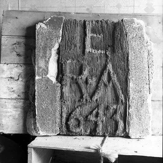 |
| A carved oak panel bears the date 1643 and the initials R E A |
The Singleton moiety descended to William Singleton, who died in 1556 without legitimate issue. A pedigree was recorded in 1613. The estate was in 1564 sold to Sir John Southworth of Samlesbury, and afterwards changed hands, being at last in 1696 acquired by the above-named Thomas Winckley. The two moieties thus reunited have so continued to the present time.
 |
| Haymaking at Higher Brockholes Farm, Preston, in 1911 |
LOWER BROCKHOLES, now a farm-house, stands in a low situation close to the bend of the Ribble near Brockholes Bridge, facing east towards Samlesbury. It is a small two-story building of no particular interest architecturally, having been very much modernized and the exterior covered with roughcast. The windows are all modern, but the roof retains its grey stone slates, and the north wing, which has a separate gabled roof at right angles to that of the rest of the house, preserves its old half-timber construction above the ground floor, though much of the timber has been renewed. There is a wide open gabled porch of two stories projecting 9 ft. 6 in. and measuring 8 ft. square inside, over the archway of which is a stone dated 1634 with the initials and arms of Francis Bindloss, the arms with helm, crest and mantling, and a crescent for difference. The interior is structurally uninteresting, but a small oak staircase of good design with turned Jacobean balusters still remains, and in one of the bedrooms is some oak panelling forming a dado, on which is the inscription, 'Quamlibet expectes horam tibi ducere mortem, disce mori mundo Christoque resurgere spera, 1630.'
Apart from the lords of the manor there are few records of estates in the combined township, and in most cases the owners of them did not reside there. A branch of the Hoghton family, however, was in the 17th century resident in Grimsargh, and in 1653 William Hoghton, a 'delinquent,' whose estate had been ordered for sale by the Parliament, desired to compound, but was too late. William Elston and William Hoghton in 1631 paid £10 each, having refused knighthood. Several estates of Grimsargh 'Papists' were registered in 1717.
In connexion with the Church of England a chapel was erected at Grimsargh about 1716 by the efforts of Samuel Peploe, vicar of Preston. It was dedicated to St. Michael. It was entirely rebuilt in 1868–9 by the Rev. John Cross, brother of the lord of the manor. It had a separate parish assigned to it in 1875. The vicars are presented by the vicar of Preston.
A Congregational mission was begun in 1903.
St. John's College, Grimsargh, is a private adventure school for boys.
46. An indenture concerning the manor is enrolled in the Common Pleas, Mich. 3 & 4 Phil, and Mary. An account of the disputes which followed William Singleton's death will be found, with copies of depositions, in Fishwick's Preston, 94–6, 289–93. It appears that the above Henry Singleton and his nephew William son of Thomas Singleton of Bank Hall in Broughton sold the estate to John Singleton of Ripley, who in 1565 sold to Sir John Southworth. John son of Henry Singleton in 1557 gave his life interest in the Eyes in Brockholes to John Singleton of Ripley; Kuerden fol. MS. fol. 389, no. 399. Fines relating to the settlements at the same time are Pal. of Lanc. Feet of F. bdles. 17, m. 33, 80; 27, m. 171. After the death of Sir John Southworth in 1595 his estate in Brockholes, not called a manor, was said to have been held of the lord of Manchester by the three-hundredth part of a knight's fee and the rent of 4d. A free fishery in the Ribble was included; Duchy of Lanc. Inq. p.m. xvii, no. 3. By Thomas Southworth (son of Sir John) Brockholes was mortgaged and then (1620) sold to Edmund Breres of Preston, and sold again the next year to Sir Robert Bindloss of Borwick Hall. It descended to a grandson Francis and then to his sister Dorothy wife of Sir Charles Wheler, who in 1668 sold to Paul Moreau, owner of Higher Brockholes, and John Walshman of Preston, who divided the estate; Preston Chron., May 1862. Fishwick (op. cit. 96) states that Lower Brockholes was in 1682 the property of Hugh (John) Walshman, who died in 1694.
Lower Brockholes was formerly reached from Preston by a roadway known as Brockall Lane, which now forms part of the high road from Preston to Blackburn made in 1824. There was a direct way between the two towns previous to that date, but it was a mere lanc, and there was either no bridge or a very primitive one across the river at Lower Brockholes. When the road and bridge were projected the landowners and farmers petitioned Parliament to refuse authority for its construction, their contention being that if the new road were made it would give Samlesbury farmers the means of competing with them at Preston; Preston Guardian, 28 Dec. 1907.
'Townships: Grimsargh and Brockholes', in A History of the County of Lancaster:
Volume 7, (London, 1912) pp. 108-113.
British History Online - https://www.british-history.ac.uk/vch/lancs/vol7/pp108-113
It is noticeable that the author's comments include the following statements:
HIGHER BROCKHOLES, is architecturally uninteresting except for a portion at the east end now disused, which is a good example of 17th-century black and white work on a low stone base.
LOWER BROCKHOLES, is a small two-story building of no particular interest architecturally.
Analysing those two statements, it is strange that it is 'Lower Brockholes' which still survives today. To be fair, based on that, it is surprising that either of them is still standing.
More Modern History
Just before World War II, in 1938, some aerial photographs were taken around the area of Samlesbury. These also cover Higher Brockholes. The Farm and the surrounding field can be seen next to the River Ribble at the foot of Boilton Wood.
 |
| Higher Brockholes Farm and Surrounding Fields Next to the River Ribble |
 |
| Higher Brockholes Farm and Surrounding Fields |
The following is a view from the ground taken across one of the fields a few years earlier. It appears to be taken from the rear of the building and the hillside of Samlesbury leading towards Cuerdale can be seen in the distance.
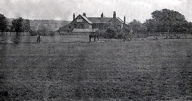 |
| Higher Brockholes Farmhouse, Preston, Circa 1935 |
Roadworks Around Brockholes
Up until the creation on the M6 Motorway, as the Preston Bypass in 1958, there had been a road from the northwest of Blackburn to the eastern side of Preston. The bridge had been widened in 1937. It is interesting to see that there are other properties near to Lower Brockholes adjacent to the bridge, which carries the A59 road now, that are not there today. They are marked on maps, but not identified as anything specific. The darker building closest to the bottom of the brow is the old Toll-bar would have been, and it was actually the Toll House.
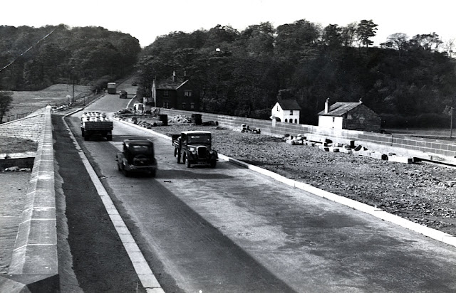 |
| Widening of Brockholes Bridge, Preston, in 1937 |
Brockholes 'Halfpenny' Bridge seen in 1907. The building that can be seen in the distance, roughly in the centre of the picture, was the toll house. This photograph is part of the Robinson Family album, and can be seen on the
Preston Digital Archive. As per the explanation in the 'History of the County of Lancaster' extract, the
Halfpenny was a reference to the price of the toll.
 |
| Brockholes 'Halfpenny' Bridge, Preston in 1907 |
Preston Digital Archive:
https://www.flickr.com/photos/rpsmithbarney/24824819770
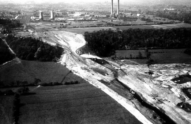
When the Motorway arrived, it crossed the River Ribble to the east of the Brockholes Bridge and cut a line from north to south up through Boilton Wood and separated Lower Brockholes from Higher Brockholes. The next photograph shows the Preston Bypass (M6) construction. This aerial view is of the excavations taking place on the north escarpment. The factory in the background is the Courtauld's Red Scar works.
 |
| Preston Bypass (M6) Construction |
The first section of the motorway, and the first motorway in the country, the Preston bypass, was built by Tarmac Construction and was opened by the then Prime Minister Harold Macmillan on 5th December 1958. There does appear to be some degree of excavation outside the boundaries of the road itself. This was possibly a small amount of quarrying to obtain some materials for the construction.
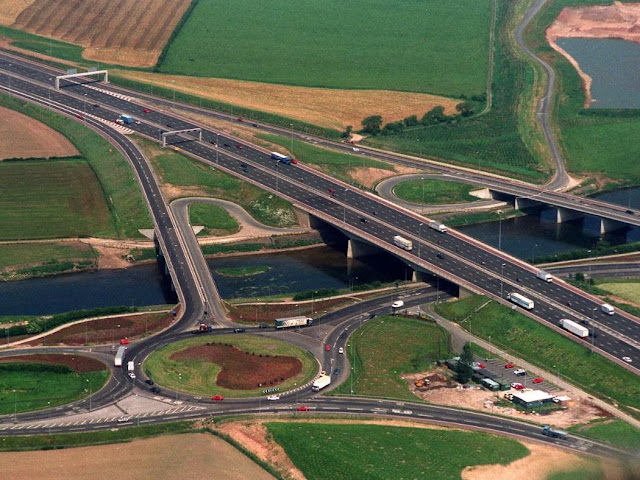
During the 1990s there was some additional work on the M6 to modify and improve the Junction around the Tickled Trout Hotel (M6 Junction 31). Much of the work was on the south side of the River Ribble. However, there was some impact on the Brockholes side, as slip roads are on both sides of the river. The aerial photographs available for this phase of construction centre around the roads and specifically Junction 31, so it is not possible to see the whole of Brockholes. However, from what can be seen to the east on the Higher Brockholes side of the M6, it is clear that much of the farmland still remains. Both photographs are taken looking roughly northwards. Although, the second photograph is orientated slightly more to the northeast.
 |
| Aerial Photograph of M6 Junction 31 During 1993 Improvements |
 |
| Aerial Photograph of M6 Junction 31 After 1993 Improvements |
On the first of these two photographs the the land to the top right of the image (north of the river and east of the motorway) appears to be untouched and still remains as farmland. On the second image, there appears to be another (access) road that has been constructed and quarrying appears to have started to the east of that.
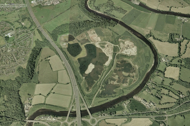
I can't find any aerial photography or pictures taken on the ground during the period after the motorway junction modifications in the 1990s, so I tried to investigate using Google Earth. There are some historical satellite image available on the PC (Personal Computer) version of the software, called Google Earth Pro, that are not available on the web version.
 |
| Satellite Photograph of Brockholes from December 2005 |
It it clear from the December 2005 Satellite Photograph that there has been quite a lot of excavation on the Higher Brockholes side of the M6 Motorway. However, at that point, it appears that not of the quarrying work ever took place in location where Higher Brockholes stood. Although, the property is not present on this image, so it must have already been demolished by that point. The quarrying took place over many years, perhaps spanning a period from the late 1980s through to the early 2000s, and seems to have moved around a lot within the lower Brockholes area. It's possible that the Farm and surrounding buildings, which was once a Hall and surrounding buildings, had been removed to facilitate some specific quarrying that I am not seeing during periods that are not covered by the aerial and satellite imagery.
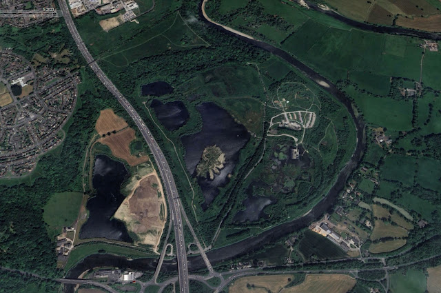
The next satellite image is relatively current. It was taken in May 2023, and shows the now well-established nature reserve. In the interim period, excavation had started on the Lower Brockholes side of the M6 Motorway. I am not sure if there are currently any plans for the land after the quarrying has finished. It would be nice to see this also become part of the Brockholes Nature Reserve.
 |
Satellite Photograph of Brockholes from May 2023
|
The following aerial image shows the work to construct the Brockholes Floating Visitor centre. The route of what was once the access road to the Hall, and subsequently to the Farm, can be seen to the left of the photograph. That is now the path taken by the Guild Wheel. Unfortunately the spot where Higher Brockholes once stood is outside the range of the photograph to the left.
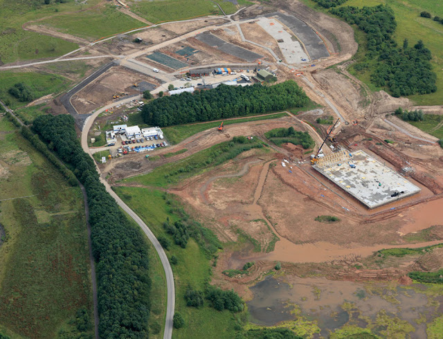 |
| Brockholes Visitor Centre During Construction |
The next image shows Higher Brockholes on an Old Ordnance Survey Map from 1912 with a modern satellite photo overlaid. There is a highlighted area covering approximately where the Higher Brockholes Hall (then Farm) and associated buildings stood. It is a shame that it is not there today. It would have made a nice feature within the Nature Reserve.
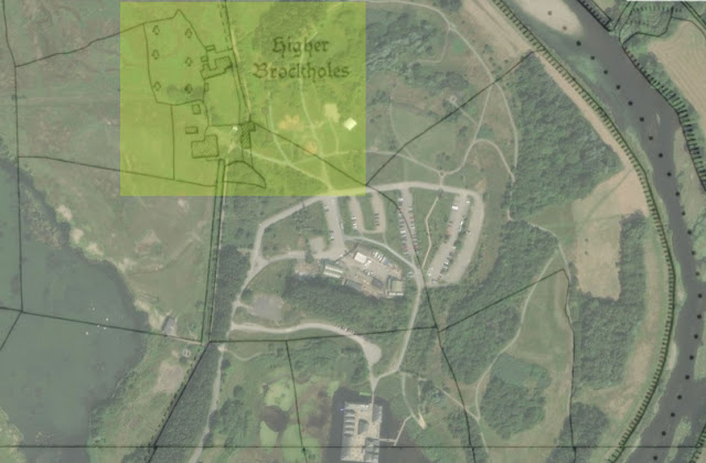 |
| Higher Brockholes on an Old OS Map - Overlaid with a Modern Satellite Image |
The next aerial photograph shows a view over the River Ribble and the Tickled Trout Hotel, which was for sale at the time. It looks towards Higher Brockholes, the Brockholes Nature Reserve, its Visitor Centre and the Ribble Valley beyond.
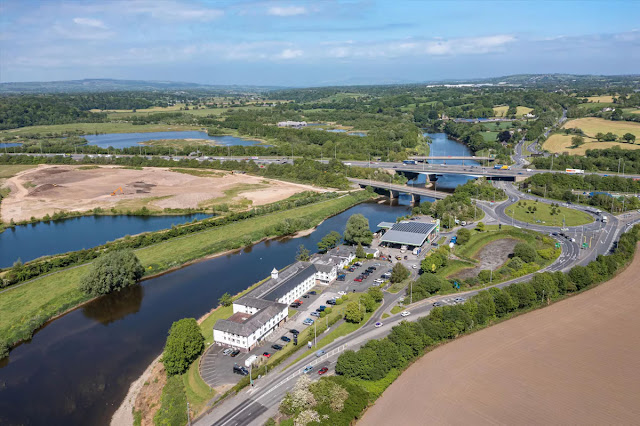 |
| Aerial View Towards the Brockholes Visitor Centre |
The final photograph is one that I took last winter of the remaining Lower Brockholes Farm. It is difficult to get close to the property from any of the public rights of way. It is a Listed Building, and it's safe to say that if Higher Brockholes had remained, I am sure that it would have been too.
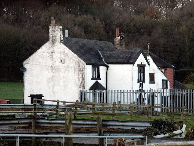 |
| Lower Brockholes Farm December 2023 |
------------------------------------------------------
Further reading and background information:
The Brockholes Lancashire Nature Reserve story by the Wildlife Trust
Lower Brockholes Farmhouse, Dated 1634 on porch, on the Historic England website
Adam Khan Architects - Brockholes Visitor Centre Project
Brockholes floating visitor centre article from Building Magazine 2010
High(er) Brockholes photographs from the Ralph Cross Collection
Relation on Pennine Horizons Digital Archive
---------------------------------------------------------------------------
My accounts of the local area - About this Blog


Comments
Post a Comment