FAREWELL TO THE SUMMIT
The following text is taken from a 1968 publication entitled "FAREWELL TO THE SUMMIT" that was given to me by a friend who has a mutual interest in Canal related history.
It was written by Ian Moss to accompany a visit to the Southern section of the Lancaster Canal towards Walton Summit and the adjoining Tram Road to Preston. At the time, both were in a state of disuse, but were much more visible than today. At the time of the visit, the construction of the M61 Motorway was underway, and this highway cut through the canal. Thus, putting it out of action forever.
I am not sure if there are any copyright issues with sharing the text. My understanding is that it isn't a formal book publication with an ISBN etc. I am only trying to get this information out to a wider audience, and share an account from over half a century ago. If you know otherwise, please let me know. If is causing anyone an issue, I can remove it. The text has been modified slightly, as I ran the output of a scan through an OCR (Optical Character Recognition) software and then had to adjust it in Google Documents.
==######====######====######====######====######==
 |
| RAILWAY & CANAL HISTORICAL SOCIETY FAREWELL TO THE SUMMIT by Ian Moss |
RAILWAY & CANAL HISTORICAL SOCIETY
FAREWELL TO THE SUMMIT
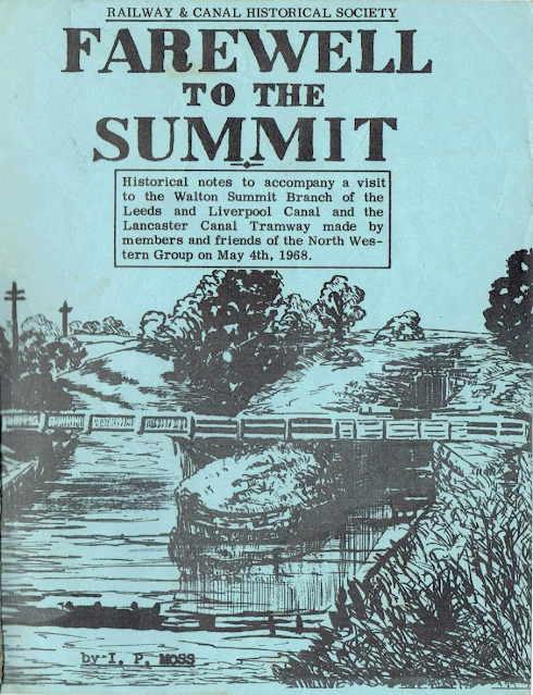
Historical notes to accompany a visit to the Walton Summit Branch of the Leeds and Liverpool Canal and the Lancaster Canal Tramway made by members and friends of the North Western Group on May 4th, 1968.
==######====######====######====######====######==
On 1st June, 1883 Clement E. Stretton, during a walk over the line of the Tramway read, at Walton Summit, a paper on "The History of the Preston & Walton Summit Plateway". It was read again twenty years later on the 100th Anniversary of the opening. We are not the first - though we are probably the last.
==######====######====######====######====######==
A DESCRIPTION OF THE WALK - CHORLEY TO PRESTON
Our journey begins at Botany Bay Where the Chorley-Blackburn Road (A674) crosses the south End of the Lancaster Canal. Of recent months the area has been razed in connection with the works for the new motorway (M61) which are advancing rapidly. A few hundred yards on we pass under the nine arch viaduct which was built in 1868 to carry the joint L.N.W.R.-L&Y line from Chorley to a junction with the East Lancashire Railway at Cherry Tree, near Blackburn. The line closed to passengers on 4th January 1960 and completely on 3rd January 1966. The contract for the M61 includes demolition of this viaduct during the next few months. Another few hundred yards would, in Rennie's original plan, have seen the junction of the Duxbury Branch, which, almost three miles long, was to have served the centre of Chorley and the coal pits which were just to the South of the town. I have never seen reference to it other than on this plan- probably no further action was taken. There is a winding hole nearby for boats serving Hope Mill (now a "chicken" factory, lately a cotton mill and on the site of a mordant works) and the Moss Lane Malt Kilns a little way ahead. At Moss Lane bridge we see the junction with the main line locks rising away to the right. Immediately below the locks is the building of the old Whittle Springs brewery which closed in the 1920s after a working life of some sixty years. In grounds near the brewery are the "Springs" -spa waters which were discovered in 1836 and made the area into something of a tourist centre- Chorley station once bore the sub-title "for Whittle Springs" and the Howard Arms (in the springs grounds) was erected by H. Heys Esq. in 1847. Mr. Heys "..... expended a considerable sum of money in fitting baths and laying out pleasure grounds...." His efforts remain in the grounds of' the still flourishing Howard Arms. The brewery is now a chicken factory.
The locks, which make connection with the Leeds & Liverpool were built by the Lancaster Canal Co. although they are of typical Leeds & Liverpool design and construction was presumably under that Company's supervision. The design of the paddles (Cloughs' on this canal) is very different from narrow canal practice, especially on the top gates where the gate paddles slide rather like camera shutters and the ground paddles are operated by a worm and nut. We shall walk up this very attractive flight. Half way up, on the left is a farm and a group of cottages owned by the canal co.
Before the war there were a few horses kept on the farm to assist pairs of boats through the locks. In the valley to the West is a factory chimney marked on the 1846 0.S. map as "Denham Print Works". No local residents - and I have consulted some who are well over eighty - remember the works in action. At the top lock is the lock house and the toll office (this was of course a junction of canal properties). Mr. W. Wilson who lives here succeeded his father as lock keeper.
To return to the junction and walk along the Branch - after a quarter of a mile we come to the first bridge and a wharf - for about three years the terminus of the canal. A private house near the wharf was at one time the Navigation Inn. Beyond this is a shallow cutting, which after a few hundred yards dramatically opens out onto an embankment across the Lostock Valley. The river and a footpath are carried through the embankment by a tunnel which looks remarkably like a canal tunnel. Immediately following the embankment are the Whittle Tunnels - two tunnels separated by a deep cutting. Originally there was one long tunnel but it collapsed in 1837 and was opened out. The towpath through the tunnels is in poor condition and in the cutting it is overgrown with shrubs; the prudent might prefer to follow the road over them.
The canal emerges into the centre of the village of Whittle. This was well served by the canal - the quarry through which the tunnels are cut, several cotton works, the Co-op and other coal merchants, and a chemical works all made use of the canal.
The road which crosses the canal twice in a short distance was the main road between Chorley and Preston until the building of the lower road in about 1830. At one time, to serve canal and stagecoach there were ten pubs in less than two miles. There are still five. Of those that have closed the "Paletot" now a private house still bravely bears its name and the inscription "Whittle Springs Noted Ales" although it has been closed for at least forty years.
We pass the site of a chemical works and the Co-op coal yard and take a footpath on the non-towpath side of the canal. Along here is an old lime kiln to remind us of one of the canal's original functions. We cross to the towpath by a wooden accommodation bridge and walk the last few yards to our lunchtime stop at Radburn Basin.
A road from Leyland to Blackburn crosses Here and for about five years, from 1810, goods were transhipped to road and taken to Blackburn for onward. conveyance by the Leeds & Liverpool Canal.
Next to the bridge a mile post tells us that we are one mile from the Summit. This last mile makes a very attractive and often lonely walk.
The towpath is muddy and overgrown at first, but rather surprisingly it improves towards the Summit. We pass a winding hole and shortly afterwards a wooden footbridge next to a disused waterworks, which I believe to have been the last commercial user of the branch (in about 1932), the canal now takes a sharp turn to the left on low embankment and passes under the last bridge - Summit Bridge. From here to the summit the canal is in a shallow cutting. This last few hundred yards has two towpaths, but one is now impassable. As the basin is reached we see the "3 mile" post.
The Summit affords an excellent view of the Ribble Valley and it is worth pausing here to examine the remains of a warehouse, the tramway bed and a few almost unrecognisable hulks of boats. It is said locally that within living memory it was well worthwhile dragging the bottom of the canal to eke out coal supplies in time of shortage.
==######====######====######====######====######==
The line of the inclined plane is still clear and there are a fair number of sleepers still to be seen - not in their original position, for they have at some time been used to make a roadbed for the farm. The incline is on private property and permission must be sought from Summit Farm (at the bottom of the hill) before venturing on it. There is a public footpath across the end of the basins at right angles to the general line of the canal. The one to the left (facing Preston) leads to Gough Lane which falls down the same hill as the incline and crosses its line at the bottom.
The engine house was on the site of Summit Farm. The line of the tramway is clear until it crosses Kellet Lane, where a house and a bungalow have been built on the line. For about a mile beyond this the track is in fields and is not very near to a public footpath. It is not convenient for a large party to follow it. In Bamber Bridge the line crosses the A6 next to the McKenzie Arms; until very recently one could have Joined it again here but in these last months a housing estate has been built on the line (some of the land was purchased from the British Railways Board.). We can briefly pick up the line again as it passes under the railway just west of Bamber Bridge Station (at the point where the line into Preston leaves that used by direct Blackburn-Liverpool traffic) and there are hints of it in fields a little further on but much of the area is covered with housing.
However, for the last two miles the line is complete - indeed it is a public footpath. The path begins near Todd Lane - it is clearly marked on the O.S. map - and leads down to the "Old Tram Bridge" in Avenham Park.
There are several sleepers still in situ and some in nearby stone walls. To the right of the slope at Carr Wood the line appears to branch, possibly to the site of the original engine worked incline plane. A long tree-lined embankment (with the East Lancashire line to the left) brings us to the Old Tram Bridge across the Ribble. The present concrete structure is in the same style as the one which carried the tramway. The Avenham incline is now a park footpath with the site of the engine occupied by at park shelter. The tramway line veers to the left at the top of the incline and continues as a park footpath for some way but is eventually lost in housing built late last century. The only remaining signs of the tramway are the abutments of a bridge in Garden St. and one entrance of the Tunnel, which took it under Fishergate this, in enlarged form is the road access to Butler St Goods depot. Over a mile of the North End of the Canal in Preston has now been dewatered, a Technical College has been built on the end basins and an aqueduct (in Aqueduct St.) has been demolished for road widening.
 | |
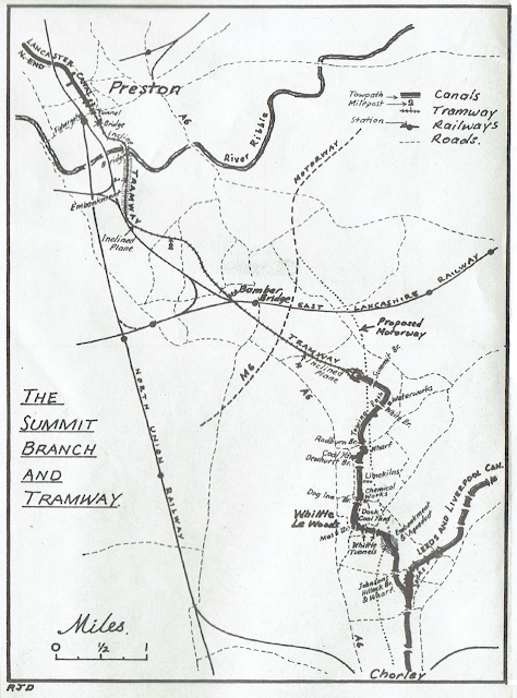
| The Summit Branch and Tramway Map from FAREWELL TO THE SUMMIT by Ian Moss |
==######====######====######====######====######==
THE HISTORY OF THE BRANCH & TRAMROAD
 |
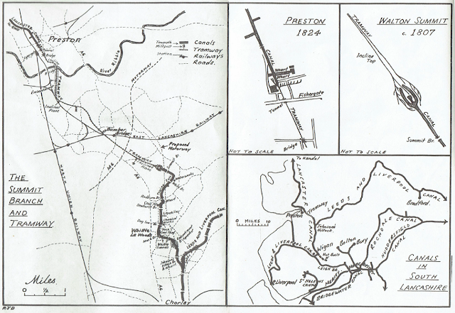
| Maps from FAREWELL TO THE SUMMIT by Ian Moss |
==######====######====######====######====######==
Brindle Waterworks is close to the canal near White's bridge and according to local boatmen and Mr W. Wilson lock keeper's son and subsequently lock keeper at Johnson's Hillock for most of the present century it was one of the last places to be served commercially by the canal.
A request for information about the waterworks produced a very full history from Mr. J.A. Bailey, the Preston and District Waterboard Engineer. The Board have no record of the works being served by the canal (presumably this is not evidence that the canal was never so used), but they have records that a borehole was made close to the South Bank just East of White Bridge. A pumping house, treatment house and reservoir were built in 1883. In 1896 the supply to Brindle Works was augmented by an 8" main from the Thirlmere Aqueduct at Hoghton.
By 1906 the supply from the borehole was diminishing and in 1921 the well was closed and the machinery sold. The works has now been demolished but the old main from it is still in use and the old construction can still be seen - the main changes from round to square section and the water is carried across the canal by a rectangular wrought iron box girder. The pipe on the other side of the bridge is a feed from Thirlmere to Walton-le-Dale laid in 1961.
Another main from the Thirlmere Aqueduct passes along the towpath at Whittle Tunnels.
==######====######====######====######====######==
The Lord Nelson - date stone 1668 - was originally a farmhouse which ran the Inn trade as a sideline. Its early name is not known, but since it was also a tannery it is at least possible that the name was connected with that trade; it was probably renamed very soon after Trafalgar. Kuerden, a local historian writing towards the end of the 17th century calls it a "fair stone building the inheritance of Mr Thomas Walmsley."
Walmsley was a relation of Judge Walmsley well known in the reign of Elizabeth I; there is a hotel named after him at Whalley.
THE RIBBLE BRIDGES
Preston is the lowest crossing point on the Ribble and the seven bridges which cross the River in less than two miles are perhaps worthy of some description even if the author is not in possession of full details. The lowest, most Westerly, bridge is that carrying the Liverpool Road, the A59 which was built fairly late last century. Some 400 yards upstream is the old road bridge which, erected by public subscription in 1755 fell down the same year. It was re-erected in 1759. It is now open for pedestrians only.
There follow three railway bridges - the first carried the west Lancashire line from Southport and was opened in 1880. The West Lancs was absorbed by the Lancashire and Yorkshire in 1897 and from then its trains were directed into the main Preston station - the West Lancs Bridge was subsequently goods only. Next is the giant North Union Bridge which carries the West Coast main line. Opened in 1838 it was built by one McMahon who estimated for one arch and, in submitting his tender forgot to multiply by five; happily he recouped his losses on other parts of his contract. The East Lancs
(Lancs & Yorks) Bridge carrying the line from Blackburn and Liverpool is somewhat overshadowed by its North Union neighbour. Opened in the late 1840s it leads to what are still known as the "East Lanes" platforms at Preston Station. The East Lanes had, for a little time, enjoyed access to Preston only via the North Union.
Just upstream is the Old Tramway Bridge and then after a half mile gap the road bridge carrying the A6, formerly the Preston & Wigan (North of Yarrow) Turnpike. The next crossing is nine miles away, at Ribchester.
[Ash Preston - If you don't know about the Bridge at Brockholes Brow taking the A59 towards Blackburn and then Yorkshire]
==######====######====######====######====######==
Acknowledgements
====######====######====######====######====######====
The author would like to thank Mr. J. Freeman British Waterways Area Engineer for permission to visit canal property, Mr & Mrs Bell of Summit Farm for permission to walk down the site of the Walton Summit inclined plane, Mr Leslie Wain landlord of the "Lord Nelson" for hospitality during the walk and Mr. W. Wilson, lock keeper at Johnson's Hill for many years, for much informal information about the canal given over many years.
====######====######====######====######====######====
The cover is a drawing by Mr Norman Wilkinson of the Verdin Grammar School, Winsford, showing the Junction of the Summit Branch and the Leeds & Liverpool Main Line.
====######====######====######====######====######====
The Maps were drawn by RJ. Dean, Secretary of the Group
====######====######====######====######====######====
Published by the Railway & Canal Historical Society (N.W. Groups) May 1968.
====######====######====######====######====######====
Published by the Railway & Canal Historical Society (N.W. Group).
Further copies of this booklet may be obtained from the following address for 3/6d post free:
R.J. Dean.
Group Secretary,
R. & C. H. S.
5, Marbury Road,
Vicar's Cross,
CHESTER.
Comments
Post a Comment