The Cuerdale Hoard is a collection of Viking-era silver coins and bullion that was discovered in the Cuerdale area near Preston, Lancashire, England in 1840. Although not conclusively proven, the hoard is believed to have been buried by Vikings during one of their raids in England during the late 9th century.
The Cuerdale Hoard was found by a group of workmen repairing the embankment of the river. It was in a lead box, which shows evidence of the hoard having been parcelled into small bags or packages. The majority of the treasure from the Cuerdale Hoard is now housed in the British Museum in London, where it is on display for the public to see. The hoard is considered to be one of the most significant Viking discoveries ever made in the British Isles, and it provides valuable insights into the Viking culture and their trade and economic activities during this period.
Whilst I have lived in the area all my life, I had no recollection of having learnt about this history in my younger days. I first became properly aware of it a few years ago. I recently went for a couple of walks in the area, to see if I could find any evidence of this historical event whilst also exploring the public rights of way.
X Does NOT Mark the Spot
I had read a few articles about and seen a few images of a memorial stone but, even though people had pointed out where it should be, I hadn't been able to spot any evidence. I'd even watched some footage of a man flying a drone over the area, and he hadn't been able to find it either. The location is by the local river, the Ribble, and obviously courses of waterways change naturally over time. The site is on some farmland, but there is a cordoned-off area that has been worked on by the Ribble Rivers Trust. The land has always been susceptible to subsidence caused by river water erosion, and they have been planting trees to try and stabilise the land.
The stone marking site of the Cuerdale Hoard find on 15th May 1840, originally looked like the picture below. This photograph was taken around 1937.
 |
| Cuerdale Hoard - Stone Marker |
If it hadn't been washed away, it was possible that it had been lost in amongst the tree planting. However, that seemed a bit unlikely. I had found some pictorial evidence from less than 10 years ago. This picture is from about 2008, so is a little longer ago.
 |
Cuerdale Stone - A stone commemorating where the Cuerdale Hoard was discovered |
I read an article by The Lancashire Archaeological Society, and they appear to have been on a visit during September 2014. This page documents the LAS visit to Cuerdale:
From St Leonard’s Church, they crossed the road and headed down the footpath. They travelled across the fields to the find site. They ended up in a little depression set back from the bank of the Ribble not far from Cuerdale Hall. They discovered the location marked by a carved stone, now unfortunately almost illegible. The words “Site of Cuerdale Hoard” could just about be made out.
All the other markers or coordinates that I had discovered through Internet searches were definitely in the right proximity, but nothing seemed to accurately pinpoint the precise spot.
If at First, You Don't Succeed...
On Sunday 26th March 2023, I decided to have another walk in that direction. I marked some potential locations on my what3words App, based on the information that I had previously found and headed off toward Cuerdale Hall.
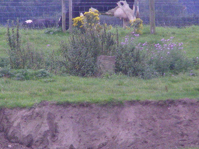
On my arrival in Cuerdale, I decided that the stone, if it still existed, must be within the area that had been fenced off by the Ribble Rivers Trust. Whilst there were warnings about illegal fishing, I didn't see anything to say the land was private, or access was restricted. I was conscious of damaging any of the barrier fencing as I climbed in, so I chose to scale a sturdy section that the adjacent farm gate was attached to.
To my surprise, I the stone was practically right there in front of me when I descended the opposite side of the fence. I must have walked past the stone on several occasions before and just not spotted the top of it.
 |
| The location of the Cuerdale Hoard Stone |
 | ||
| Cuerdale Stone commemorating where the Cuerdale Hoard was discovered |
 |
| Another view of the location of the Cuerdale Hoard Stone |
 |
| A view towards the stone's location on the farm track beyond the footpath. |
Whilst I was in the location, I marked the spot with my App. The details are as follows:
what3words - ///index.begin.spray
Latitude & Longitude - 53.759905, -2.64921
British National Grid - 357296,429478
The what3words address refers to a 3 metre square location. Tap the link or enter the 3 words into the free what3words app to find it.
 |
| Cuerdale Hoard Stone location - w3w index.begin.spray |
If you look at the satellite image, on which I have marked the stone's location, you can see where an area of bedrock in the river is situated. This area would have historically been used to cross the river. My understanding is that Penwortham Old Bridge was the first bridge to cross the River Ribble in the Preston area, and that wasn't constructed until 1755.
The History of the Cuerdale Hoard
The Cuerdale Hoard is one of the largest Viking silver hoards ever found, four times larger than any of its nearest rival discovered in Britain or Ireland, and second only to the Spillings Hoard found on Gotland, Sweden. It was found in 1840 by workmen digging on the embankment of the River Ribble near Cuerdale Hall, Preston, Lancashire. The hoard was buried in a lead chest, and is dated to the Viking period.
It is the largest hoard of its kind ever found in England. Among its 40 kilos of valuables were 7,500 coins and 1,000 ingots, ornaments and cut fragments of silver. The treasure contained Anglo-Saxon and Viking coins, as well as coins from the Middle East, Italy and the Frankish kingdom. There was also bullion from Ireland. Some coins dating to AD901-905 give a terminal date for the hoard. This is the probable date of burial of the treasure.
Soon after its discovery, the hoard was dispersed to more than 170 recipients. Some items survive in the British Museum and the National Museums, Liverpool. The objects pictured in the photograph below were acquired by Sir John Evans and presented to the University of Oxford's Ashmolean Museum by his son Sir Arthur Evans in 1909. Objects from the hoard can be seen on display in the ‘England 400-1600’ gallery on the second floor of the Ashmolean Museum.
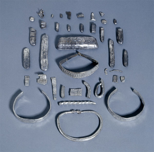 |
| Objects from the Cuerdale Hoard - Ashmolean Museum ref. AN1909.519-551 |
Prompt action by the landowner's bailiff ensured that almost all the hoard was retrieved; the labourers were allowed to retain one coin each for themselves. It was declared Treasure Trove at an inquest on 15 August 1840, the property of Queen Victoria in right of her Duchy of Lancaster; the Duchy then passed it to the British Museum for examination prior to its distribution. The lion's share, however, was allocated to the British Museum.
Other reading:
BBC History - https://www.bbc.co.uk/history/ancient/vikings/cuerdale_01.shtml
Wikipedia - https://www.wikiwand.com/en/Cuerdale_Hoard
---------------------------------------------------------------------------